UX Design, UI Design, UX Research
Lead Product Designer, UX Research
Jan 2024 - Aug 2024
Skills
My Role
Duration
RIT HYPERWALK - REIMAGINED FOR ACCESIBILITY
Navigating large university campuses, especially complex indoor pathways, can be confusing and inefficient. Existing campus maps lack real-time, intuitive guidance, making it difficult for students, faculty, and visitors to find their way efficiently. Accessibility concerns further complicate navigation for individuals with mobility challenges, often leading to frustration and delays.
Problem
Solution
HyperWalk is a dynamic indoor navigation system designed to simplify wayfinding within RIT's campus. By integrating real-time routing, accessibility-aware pathways, and an intuitive interface, it enhances user experience by providing clear, step-by-step navigation. Whether guiding students to classrooms, faculty offices, or event spaces, HyperWalk ensures a seamless and efficient journey tailored to individual needs.
PERSONAS
How Might We...
Create an intuitive and accessible indoor navigation system that helps students, faculty, and visitors efficiently navigate RIT’s campus while addressing mobility and accessibility challenges?
Navigating RIT’s campus, especially its interconnected indoor pathways, is often confusing and inefficient. Existing campus maps provide static, high-level overviews but lack real-time, context-aware guidance. This results in students, faculty, and visitors struggling to find specific locations, leading to unnecessary delays and frustration. Additionally, the current system does not account for accessibility needs, making it difficult for individuals with mobility challenges to find optimal routes.With no clear way to distinguish the most efficient paths, users often resort to trial and error, further impacting their overall campus experience.
About the Problem
Persona: The Student
Age : 21
Occupation : College Student
Challenges
Struggles to find the fastest route between classes, especially in large or unfamiliar buildings.
Relies on mobile maps but finds them slow and sometimes inaccurate indoors
Background : a tech-savvy student who frequently moves between classes, the library, and campus facilities.
Solution Needs.
A quick, intuitive navigation system that provides real-time directions.
Features like accessibility-friendly routes for stairs, elevators, and ramps
Quotes:
"I don’t have time to get lost between classes. I need a navigation system that helps me move fast and smart"
Persona: The Elder Individual
Age : 68
Occupation : Retired Teacher, Volunteer at Community Center
Challenges
Difficulty reading maps due to vision issues
Avoids large campus spaces because of mobility concerns
Background : enjoys staying active and visits RIT for lifelong learning programs, community events, and lectures. Navigation can be overwhelming.
Solution Needs
Indoor guidance to help locate elevators, seating areas, and restrooms
A voice-guided, easy-to-read navigation system with larger text and contrast.
Quotes:
"A clear, simple navigation guide would make it so much easier."

Persona: The Individual with an Intellectual Disability
Age : 30
Occupation : Part-time Employee at Campus Café
Challenges
Difficulty understanding complex directions or multitasking
Needs a straightforward, predictable way to navigate
Background : has mild cognitive impairment, handicapped and sometimes struggles with directions, remembering routes, and adapting to changes
Solution Needs
A simple, step-by-step visual guide with symbols instead of complex text
Landmarks-based navigation (e.g., "Turn left at the library" instead of "Walk 200 feet")
Quotes:
"I like knowing exactly where to go. If something changes, I need a clear, easy way to understand what to do next"
Press Play Button to View
PROBLEMS & INSIGHTS
final design
REFLECTION
Navigating RIT’s campus, especially through indoor pathways and tunnels, presents significant challenges for students. Many rely on Google Maps, which lacks indoor navigation support, leading to confusion, inefficiency, and even safety risks—especially in harsh weather conditions.
This project explores ways to improve campus navigation through a digital wayfinding solution designed to provide clear, accessible, and real-time indoor navigation.
I conducted interviews with RIT students to understand their experiences navigating through campus. The following insights emerged:
No Internet in Tunnels: Students often avoid tunnels because they lose network access and can't rely on digital maps.
Way-finding Challenges: Students frequently get lost due to lack of signage and unclear pathways in underground tunnels and buildings.
Weather-Dependent Navigation: Many students walk outdoors in heavy snow simply because they are unaware of tunnel routes. This results in slips, falls, and injuries.
Inefficient Navigation for Events & Orientation: Students struggle to find event locations due to unclear room names and inconsistent location markings.
Locked Exits & Fire Safety Confusion: Some students have mistakenly fire doors, leading to them getting locked outside and wasting additional time.
To improve campus navigation, I designed a mobile-first wayfinding solution that provides:
✅ Offline Navigation Support – Preloaded maps or beacon-based navigation to work without an internet connection.
✅ AR/VR/XR Navigation – Students can lift their phone and see real-time directions instead of manually searching for signs.
✅ Weather-Conscious Path Recommendations – A feature that suggests whether to use tunnels or outdoor paths based on real-time
✅ Interactive Indoor Maps – A directory that highlights tunnels, key resources, and hidden campus spaces.
✅ Optimized Routes for Efficiency – Time-saving shortcuts through tunnels and buildings for students in a hurry.

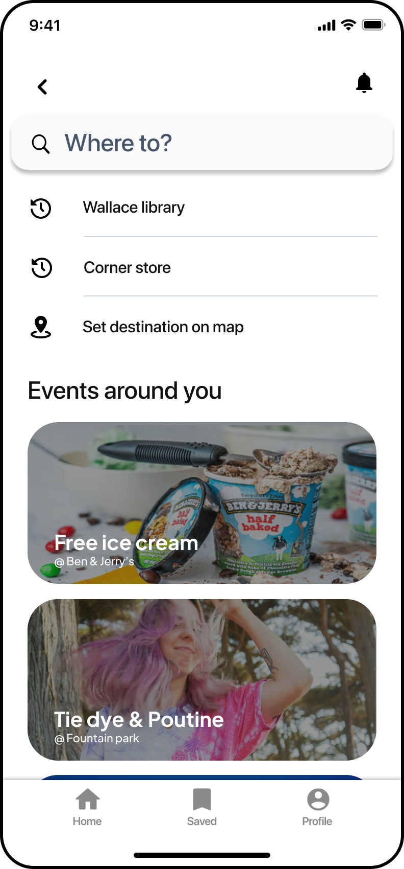


Quick access to saved locations and aesthetically enhanced event discovery
Improved RIT Mobile Map
Enhanced campus navigation with stairs, elevators and wheelchair-friendly routes,
Accessible & Smart Navigation
You can view detailed directions along with various accessible routes, ensuring that you have multiple options tailored to your specific needs.
Indoor Navigation Guide with VR
Once you access the VR version, you will start from the designated starting point, where you can view step-by-step directions with a clearly visible arrow guiding you along your intended route.
Indoor Navigation Guide with VR
Working on the Hyperwalk VR map for RIT was an exciting challenge, allowing me to blend interactive design with spatial navigation to create an immersive experience. This project pushed me to think beyond traditional map interfaces and focus on how virtual reality can enhance the way users interact with large, complex environments like the RIT campus.
One of the key insights from this project was the importance of intuitive navigation. In VR, it’s easy for users to feel disoriented, especially with the existing map navigation, so ensuring that they can easily find their way around was essential. I focused on clear visual cues and directional indicators that guide users without overwhelming them, allowing for a smooth and enjoyable experience.
Overall, working on Hyperwalk reinforced my understanding of the power of immersive technologies in enhancing navigation and interaction. It deepened my appreciation for the need to balance user needs with the capabilities of the technology, ensuring that new experiences feel natural and intuitive while adding real value.


See Final Design
RIT Hyperwalk
prajyot
